The VULCARE-FATE (Global change impact on VULnerable CARbon reservoirs: carbon sequestration and emissions in soils and waters From the Arctic To the Equator) project was selected along with five other projects in the Belmont Forum’s “Towards Sustainability of Soils and Groundwater for Society (Soils 2020)” call from among 17 eligible proposals received. The kick-off meeting will be held in June 2021 at the Sustainability Research & Innovation Congress 2021 in Brisbane, Australia.
sortium VULCAR-FATE, led by IRD, includes IFP Energies nouvelles (IFPEN, France), Florida State University (FSU, USA) and Tomsk State University (Russian Federation) as funded institutions. As self-funded partners, the consortium also involves the Universidad Autónoma de Barcelona (UAB, Spain), the Centre National de la Recherche Scientifique (CNRS, France), and the non-governmental organization The Nature Conservancy (TNC-Gabon, USA), the largest conservation NGO in the world. The project also involves numerous academic and stakeholder partners in Gabon and the Russian Federation.

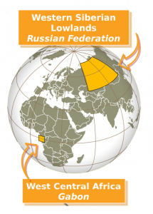
VULCAR-FATE proposes to work in two emblematic, largely preserved, sparsely populated (less than 5 people per km2) but threatened socio-ecosystems in Gabon and the Russian Federation, both of which are at the forefront of many critical climate change issues:
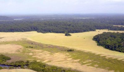
- The Ogooué river basin in Atlantic Central Africa occupies about 80% of the total area of Gabon. It is mainly covered with tropical rainforests but also a significant proportion of savannas and wetlands,
- The West Siberian Lowlands, a mostly flat geographic region of Russia, 70% covered by wetlands, with gradients ranging from (1) areas without permafrost to areas of permanent permafrost and (2) from taiga to tundra.
In both regions, we observe very contrasting vegetation classes (forest vs. savanna and taiga vs. tundra) that differ strongly in albedo and in carbon storage levels and modalities. Understanding the dynamics of vegetation cover induced by global change is therefore essential for the future of carbon balance and stocks. Fires are ubiquitous, although crown fires in taiga are inherently different from surface fires in savanna. But in both cases, interactions and feedbacks between vegetation states and fire regimes diversify the pathways that vegetation is likely to follow under climate change. In addition, human practices also influence the fire regime. While forest encroachment on savannahs is a widespread pattern in West and Central Africa over the past 70 years, it suffers from exceptions that require investigation. Similarly, the northward (upward) movement of the tree line is not ubiquitous. Notably, artificial tundra and “paludification” contribute to uncertainty about future changes in the tundra taiga boundary.
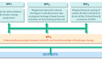
The specific objectives
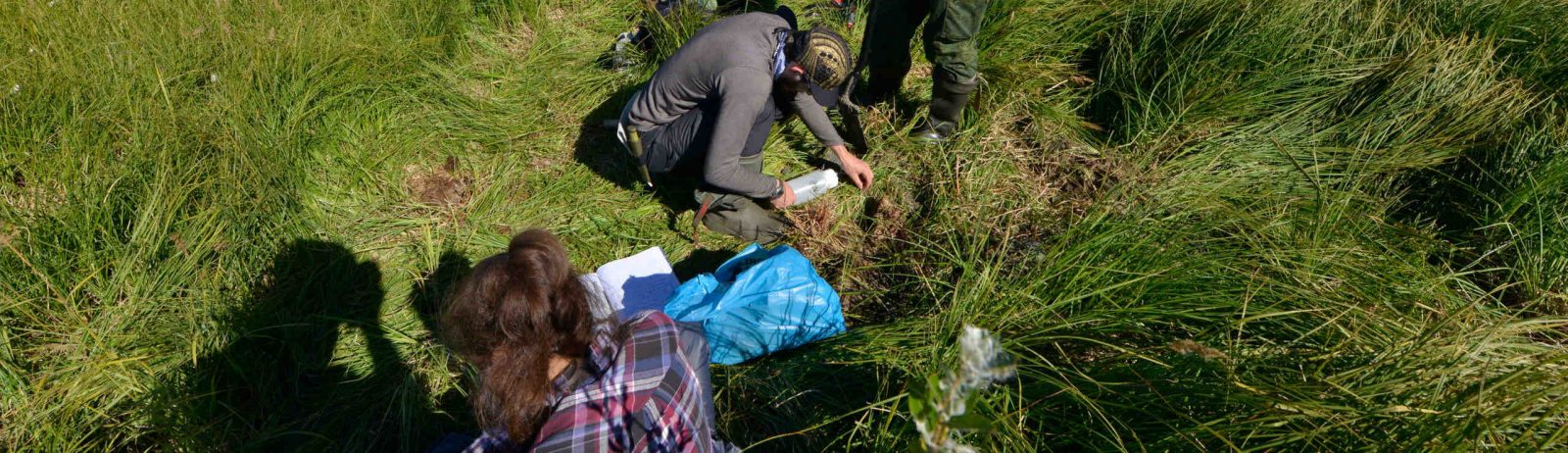
SO1: Monitor the water balance, land use/cover changes and carbon sequestration by vegetation biomass (including the tipping points between contrasted vegetation types from climate-induced, fire-mediated dynamics in both regions characterized by mosaics of open -savannah/tundra- and forest vegetation) to constrain Earth SystemModels(41) and numerical models of geological processes and water flow;
SO2: Assess and compare carbon storage, export and emissions from two, little-recognized and fragile soil classes common to both regions (podzols and anthrosols), prone to carbon sequestration and nowadays threatened by human-induced deteriorations;s;
SO3: Assess and model by a hydrological continuum approach taking advantage of existing research stations and environmental observatories (1) the loss and/or sequestration/burial of carbon, including black carbon, and other nutrients and metals from weathering/erosion and/or sedimentation processes and (2) the exports from rivers and groundwater to oceans, and subsequently the GHG emissions from soils to hydrosystems (i.e. groundwater, rivers, lakes and wetlands);
SO4: Coordinate a public-private partnership (research organisations, industries, governmental agencies, NGOs and local communities) to (1) evaluate their use and perception of the landscape as well as their responses to environmental changes and adaptation to future environments and (2) design knowledge-based scenarios, decision support data/tools and options for sustainable management practices and implement capacity-building activities for young scientists, land managers and decision makers;
SO5: Disseminate and communicate towards the public at large and other audiences to raise awareness of soil, water, the critical zone concept, and threats related to their degradation, transfer the project’s results, and to generate changes in soil/water management policies and practices.
Les résultats attendus
SO1:
R1: Innovative solutions for long-term Earth observation systems based on geospatial analyses validated by ground measurements to establish (1) a robust database for water balance components and (2) a mapping of spatial variation of aboveground biomass (including areas with high carbon stock) and emission factors in the case of deforestation/degradation, contribution to the estimation of regional/continental carbon sequestration;
R2: Mapping and understanding of land use dynamics (wildfires, etc.);
R3: : Improved forward models combining local and regional approaches to assess the ecosystem’s state for the next 30-100 years;
SO2:
R1: Mapping of the extend of podzols and anthrosols and evaluation of their carbon stocks;
SO3:
R1: Constrained carbon and GHG budget in terms of storage in soils and exchange fluxes between inland waters and atmosphere;
SO4:
R1: : Roleplaying Game (RPG) and plausible scenarios (30 and 50 years) built through participatory workshops to understand how local people will try to cope with/adapt to each of the different scenarios;
R2: : Set of recommendations on mitigation of the negative climate-induced and globalization effects based on a comprehensive new, quality-controlled and freely available database including detailed maps that will help inform strategies towards sustainable management of the Critical Zone, with a focus on soils and groundwater, to support human societies and nature;
SO5:
R1: Communication and dissemination materials/supports (web pages, brochures, images, booklets, etc.) addressed to a wide range of audiences and delivering key messages;
R1: Enhanced exchanges and collaborations between soil/water public/private stakeholders and enhanced synergies between related local, national and international projects.
Impact and action plan
Impact
Strengthening public policies, models and management practices for soil and water Improved climate and terrestrial biosphere models Operationalization of transdisciplinarity Impact, engagement and dissemination plan A collective response to major societal challenges promises the best results. This requires a more coordinated approach to benefit partners by agreeing on common interests and mutual benefits, identifying excellent […]
Action plan
Approach using multi-satellite data calibrated and validated by ground measurements contrasted with information from local knowledge Monitor the water balance, changes in land use / cover carbon sequestration by plant biomass Constrain digital models of process geology and water flow Approach based on a hydrological continuum taking advantage of existing research stations Quantify and model […]